Flood advice
Community Flood Intelligence Portal
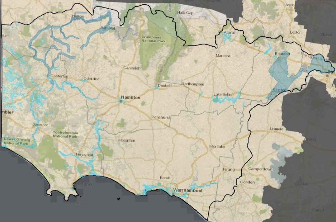
The Community Flood Intelligence Portal is an online mapping tool displaying 1% AEP flood extents where modelling exists across the Glenelg Hopkins region. The Flood Portal allows users to identify a properties risk of being impacted by 1% AEP flooding.
Please note that while every effort is made to update the modelling in the Flood Portal as it becomes available, there may be modelling that has not yet been uploaded. Please contact the Waterway Planning team on (03) 5571 2526 or planning@ghcma.vic.gov.au to confirm if there is any uncertainty.
The Flood Portal is a free service.
The data shown on the Flood Portal is not suitable for development planning purposes and should be used as an informative tool only. If you require information for planning or development purposes, you will need to apply for Flood Advice and Information via the application form below.
Application for Flood Advice and Information
Detailed flood advice is available as a fee for service product that provides a formal response on a properties flood risk through a thorough assessment of available information held by Glenelg Hopkins CMA. This option may be suitable if you are looking to develop a property which may be at risk of flooding, for pre-planning advice, or for other detailed flood risk information.
Please note that any information provided in our flood advice and information response is valid for 3 months from the date of issue. Any planning permits that are referred to the CMA outside of this 3 month timeframe from initial advice provided will be assessed on the best available information at the time of receipt of the referral as per Section 55(1) of the Planning and Environment Act 1987.
Applicable Fees
Please note: Fees have increased as of July 1, 2025.
A base application fee for flood advice of $201.70 inc. GST. is required on submission of application.
Complex applications may incur an additional application fee of $269.00 inc. GST. We will contact you if we determine your application to be considered complex and require payment of the additional fee prior to the commencement of assessment.
Concession of 15% of the total calculated fee is available for eligible customers upon proof of concession.
Additional services may be available for an additional fee. Please contact us via our details below to confirm if resourcing is available to carry out your request.
- On-site assessment/Meeting Request: $269.00 inc. GST
- Priority Service (pending availability – please contact us to confirm): $269.00 inc. GST
Current Limitations of the Community Flood Intelligence Portal
Please note that flood data for some local Councils is currently unavailable on this portal. We are working with councils to increase the availability of flood information for the whole Glenelg Hopkins region.
Contact us directly or apply for flood advice below if detailed information is not available in your area of interest.
Email: planning@ghcma.vic.gov.au
Phone: (03) 5571 2526
Flood Advice and Information Application Form
A response will be supplied within 20 working days of receipt of application and payment. We will contact you if we experience any issues throughout the assessment process which may result in any delay.
If you do not receive a receipt upon submission please contact us on 03 5571 2526 or email planning@ghcma.vic.gov.au to confirm that we have received your application.
Data Request Application
Are you seeking data and other information relating to floodplains?
If you would like to request a copy of flood modelling files or other forms of data that may be available from the CMA, please complete the online Data Request Application Form.
The application fee for a data request is $1,092.70 inc. GST
Floodplain management
Home page for our work on floodplains
What we do on the floodplain and why
Discover our role as a floodplain management authority & why we do it
Floodplain resources
Access guidelines, flood investigations, resources & online planning maps
Flood emergency information
Local flood information & resources from the authorities that manage flood emergencies