Tide gauge trigger levels for sea level rise adaptation
A new report by Glenelg Hopkins CMA has shown how Victoria’s existing tide gauges could be used more proactively in Victoria’s sea level rise adaptation planning.
The “Tide Gauge Trigger Levels for Sea Level Rise Adaptation Pathways” report has described a new way to use existing sea level monitoring gauges to reduce uncertainty in local sea level rise adaptation planning .
Key points:
Mean sea level along Victoria’s coast is rising.
Mean sea level along the Glenelg Hopkins CMA coastline has risen by about 100mm since the 1990s. The IPCC has made it clear that the rate of sea level rise around the world is tracking in the higher range of projections. The IPCC (Sept. 2019 Special Report for the Oceans and Cryosphere) has revised the projected global average increase in mean sea level by the year 2100 (relative to 1986-2005 levels) from 0.69m (likely range 0.44 to 0.96) up to 0.84m (likely range 0.61 to 1.1m), and states that up to 2m of rise by 2100 is plausible, depending on what happens to the Antarctic and Greenland ice sheets.
The results of credible research published in the Nature Climate Change Journal on 29 August 2022 shows that a minimum of 25cm of sea level rise can be expected by the year 2100, due to irreversible ice loss from Greenland alone – see Greenland ice sheet climate disequilibrium and committed sea-level rise | Nature Climate Change – summarised here ‘Zombie ice’ from Greenland will raise sea level 25 centimetres, new study finds – ABC News and here Major sea-level rise caused by melting of Greenland ice cap is ‘now inevitable’ | Sea level | The Guardian
The IPCC has also made it clear that sea level rise will continue for centuries at least. This raises a significant adaptation challenge for land use and development planning (including floodplain management) measures, so that flood risk minimisation objectives continue to be met into the future.
Objectives & Approach
The primary objective of this project was to provide a clear and practical adaptation pathway logic for Glenelg Hopkins CMA to make decisions to raise the minimum floor level requirement (Nominal Flood Protection level) for coastal development in concert with increasing flood risks associated with rising mean sea level. The logic developed can also support other important decisions such as investment in future flood investigations to plan for for event higher amounts of sea level rise.
Achieving this necessitated detailed analysis of the best available sea level rise information including the latest information from the Intergovernmental Panel on Climate Change (IPCC), followed by design of a logic for linking local sea level data (from the Portland tide gauge) with flood impact scenario mapping that accounts for higher sea level into the future (eg. 0.8m and 1.2m higher sea level scenarios). This provides a way to make adaptation decisions grounded on actual change in local sea level, rather than these decisions being guided only by assignment of uncertain timeframe estimates to future flood risk scenarios (eg. 0.8m by the year 2100). In this way the Tide Gauge Adaptation Pathway logic offers a way to making the adaptation pathway more robust, flexible and locally relevant – providing a potential means to increase local community confidence in adaptation decisions.
This information has been documented in a report titled “Tide Trigger Levels for Sea Level Rise Adaptation Pathways” – funded by DELWPs Barwon South West Climate Change Strategy Implementation grants program.
Application
The study focused on the GHCMA region, but the approach is applicable to any location along the Victorian coast.
It provides a clear logic for linking key sea level rise adaptation decisions to actual observation of local sea level as provided by a local tide gauge. In doing so it provides real world local context for making major decisions on adaptation measures which need to be implemented to keep the future costs of flooding in coastal areas within manageable limits.
The primary objective for the project (as outlined above) has been met. A significant “spin off” benefit have also been achieved in terms of understanding arising risks arising from increasing level of high tides, as outlined under Key Learnings below .
Key Learnings:
- The timeframe for realisation of significant risk thresholds is highly uncertain and depends on how quickly the world can reduce greenhouse gas emissions. Linking tide gauge levels (readings) with future flood impact scenarios and adaptation decisions could augment the existing approach to sea level rise adaptation planning, reduce uncertainty and assist in making timely decisions enabling orderly adaptation to rising sea level.
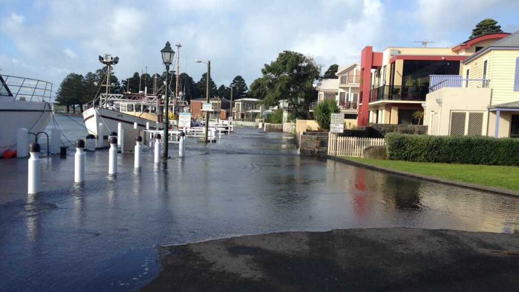
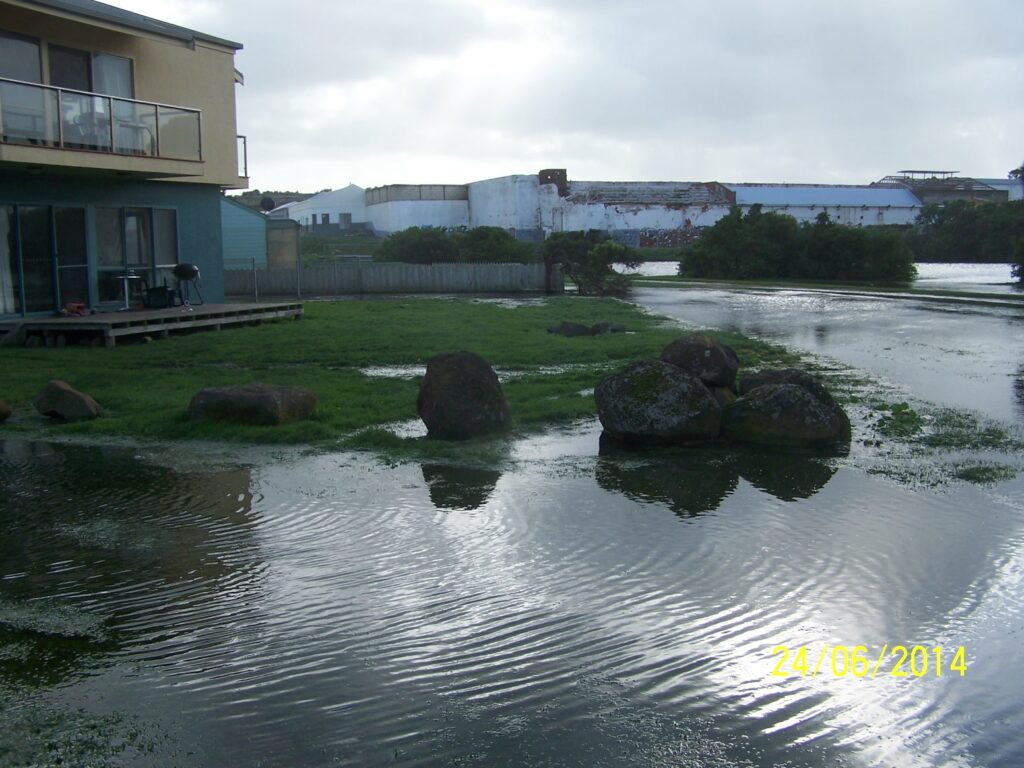
- The best available sea level rise projection information shows that by about the 2060’s, low-lying parts of places like Port Fairy and South Warrnambool may be suffering inundation to the same level as a present day 1% AEP storm tide every second week (coinciding with mean high water spring tide). Regular impacts like this will cause substantial challenges for communities due to loss of service from drainage infrastructure and low lying roads. The following images of inundation at Port Fairy and Warrnambool caused by the July 2014 storm tide, show what this future impact may look like in the absence of adaptation measures – noting that the level of inundation shown is less than what the information shows could be occurring regularly by the 2060s. The Tide Gauge Trigger Level Adaptation Pathway logic may also assist in the necessary adaptation decision making processes to deal with these regular inundation threats, in addition to supporting decisions making around minimising the impacts of large and relatively rare flood events into the future.
Acknowledgements
This project was funded by the Victorian Government through the Regional Climate Change Adaptation Strategy – Yearly Delivery Plan 2021-2022 – Barwon South West.
The project was completed by Dr Christine Lachlan Arrowsmith – Streamology Pty. Ltd.
Learn more
You can read the full report HERE